Full Article
Published online: 12 Mar 2021
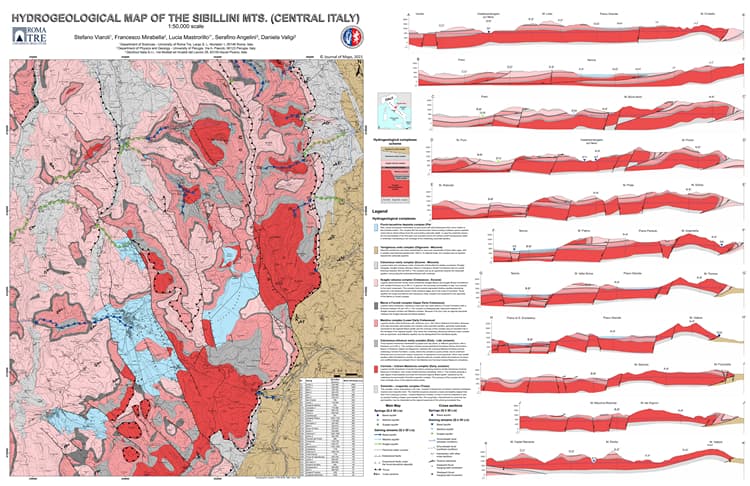
Fractured carbonate aquifers of Sibillini Mts. (Central Italy)
Journal of Maps, 17:2, 140-149, DOI: 10.1080/17445647.2021.1894252
Stefano Viaroli, Francesco Mirabella, Lucia Mastrorillo, Serafino Angelini & Daniela Valigi (2021)
To link to this article: https://doi.org/10.1080/17445647.2021.1894252
Hydrogeological Map Of The Sibillini Mts (scale 1:50.000) PDF (31,9MB)
Abstract: The aim of the present map is to illustrate a detailed pre-earthquake hydrogeological conceptual model of the Sibillini Mts. This area was struck by a prolonged seismic sequence of up to Mw 6.5 in 2016. Geological, tectonic, and hydrogeological data were collected from the literature before 2016, subsequently standardized and re-interpretated with the aim of presenting a hydrogeological map (1:50,000 scale) of the Sibillini Mts. carbonate system (Central Italy).
The map is supported by 11 hydrogeological both cross and longitudinal sections, which show the underground spatial relationship between aquifers, aquicludes, and tectonic elements. This Map provides a model of comparison for the new hydrogeological conditions emerging from the post-seismic research.
Copyright 2021 The Author(s). Published by Informa UK Limited, trading as Taylor & Francis Group on behalf of Journal of Maps